
Beginner Friendly Hikes 🥾 🐶
- Amanda Page
- Nov 26, 2021
- 8 min read
Updated: Sep 1, 2022
Whenever I get someone asking about nice, beginner friendly hikes, a few options come to mind. All of which are dog friendly because if you are going out "solo", I know that there is no greater comfort than having your canine companion with you on the trail! Since most of the people I know are in the Bangor area, here is a list of beginner friendly hikes within an hour and a half or less of Bangor.
Beech Hill Preserve 📍Rockport
This trail was heavily trafficked for the end of March when I went so I can only imagine what it is like when it is summer or fall foliage season! The walk there can be muddy in spots but easy to navigate. I will say, the walk in is nice as you pass blueberry fields, views of Penobscot Bay and Camden hills. I personally enjoyed the walk back to the vehicle as the view is beautiful!
This trail is just under 2.75 miles with a little over 400 feet of elevation gain if you follow this recording and do the small loop on the back side of the sod roofed home . Average time on this full trail loop: 1-2 hours. (However, there seems to be a lot of people who hang out here so could take longer depending on how long you visit. We also went to the Breakwater on the same day as it is close enough that you should swing over for a visit to the lighthouse!
Beginner rating: Easy.


Hart Farm 📍Holden
You will get the beauty of a large field, see some old classic cars buried in the woods, walk along the stream and try to familiarize yourself with trail signs.
The loop I have recorded, just remember to follow the blue blazes and you will be fine. I recommend doing this loop counter clockwise, as it is a little easier to follow the blazes and you get a small incline. This loop has light traffic so you may or may not see anyone out walking while you are there but there are plenty of signs!
This small loop is under 1.5 miles and less that 300 feet of elevation gain. Average time to do this trail is 1-2 hours.
Beginner rating: Easy


Ship Harbor Trail 📍Southwest Harbor (Acadia National Park)
This trailhead is in a separate parking lot but is located near another heavily trafficked trail, the Wonderland Trail. This is a well maintained loop and part of Acadia National Park so I suggest having a park pass when you go. I typically prefer to visit ANP in the off season, so I did this trail in early March and paired it with the Bass Harbor lighthouse. (There is no way I would attempt viewing this lighthouse in peak season. Not enough space for viewing in my opinion).
The tide pools are beautiful, however, too chilly to get in the water when we went. The views of the coast line are so nice. There was a little bit of ice on the trail still but not bad enough to need spikes. The plus side to visiting this trail during warmer months is the chance to view the seals that frequent here.
This trail is just shy of 1.5 miles with only 75 feet of elevation gain. There are sections that are fairly rocky that I highly recommend checking out. All trails states this loop as being wheelchair accessible but I wouldn't expect Grandma to be able to enjoy the best parts of the rocky coast line in my opinion, so I would try to find a different location. Average time on this trail is about an hour, maybe two if you have time and nice enough weather to play in the water.
Beginner Rating: Easy


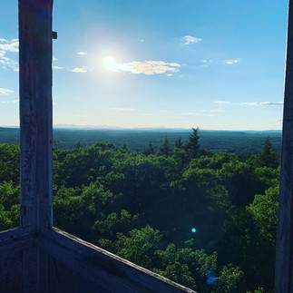
Chase Hill Fire Tower 📍Canaan
This short little trail which is about .6 out and back has about 105 feet of elevation gain. The trail is located down a dirt road but passable with a car if careful. I probably wouldn't do this one unless you are in the area or headed to another hike, only because of the short amount of time this one takes. All of the views are at the top of the tower and are so pretty for the amount of work you put in. I left Brock at the bottom of the tower, as he is very strange about most stair cases. This is a great little spot if you are local and want something to get the heart rate up slightly. It looks like locals use this as a private ATV type trail so it can be muddy in places but easily avoidable. Brock enjoyed this quick little trip to the fire tower and back. Average time spent on this hike: 30 minutes.
Beginner rating: Moderate (Mostly because of the tower)


Great Pond Mountain 📍Orland
Great Pond Mountain is part of the Great Pond Mountain Conservation Trust which offers biking, hiking, trails for equine access, campsites, boat launches and more. There are a few different trails to access the peak of Great Pond Mountain.
I do advise that when you hike here, you pay close attention to where you come out, as it is easy for a beginner to get a little turned around at the top. (I recommend taking a picture of the map at the trailhead) I have read the trails have been slightly updated compared to what is on the All Trails app.
My recording will have you drive down the hatchery road and then through the Hatchery parking lot onto what they call a "snowmobile trail" on Google maps. It makes you feel like you shouldn't be driving that way, but it is competely fine. It is the "Nature Trails Road" and then turns into the "Don Fish Trail Roadway" which will lead you to the trailhead parking lot.
This recording takes you up the Stuart Gross trail. This hike is about 2.75 miles out and back. There is a cute little bridge, some stone stair cases and some roots, moss and mud. There is a little loop at the top that would put you pretty close to 3 miles total but pay attention to the blazes if you do this section as you might get slightly confused.. Elevation gain is about 680 feet which is fairly gradual. Average time for this loop is about two hours. I recommend packing a lunch and sitting at the top. The views are beautiful and there are a few spots to stop along the way up for viewing, or eat at the summit. It is worth hanging out and taking in the views of Branch Lake and Rocky Pond.
Beginner Rating: Moderate


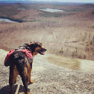
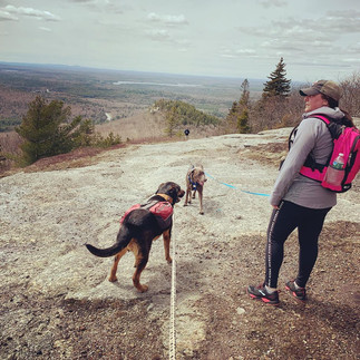
Peaked Mountain Trail (Known to locals as "Chick Hill") 📍Clifton
I have done this hike a couple of times. I would suggest as a beginner to follow the recording which brings you up the gravel roadway the whole way up. This little hike will get your heart rate up and does include some loose rock so I don't suggest attempting this in sandals (as I have seen a few hike like this).
I will say that if your dog is not well socialized and you plan on going during a weekend, please choose a time where traffic is probably low, as there are usually a lot of people using this trail. You may also see off road vehicles headed to the top on the road way so I also suggest bringing a leash, just in case you are there on a high traffic day. Fun Fact: This was the first hike I took Brock on in April of 2019.
This hike is just shy of 3 miles and has a little over 800 feet of elevation gain, which means you will get to burn a few calories. Amount of time depends on how much time you spend at the top taking photos of your surroundings and your abilities. However, I think average time spent on this hike is 1-2 hours.
Beginner rating: Moderate


Little Wilson Falls 📍Willimantic
Getting to the trail, I did park right up near the falls with my car, however, a higher clearance vehicle would have been a good idea in parts. It was fairly dry when I went as well so mud was not an issue at this time. If you don't have access to a higher clearance vehicle or 4wd, there is a mark on the directions that tells you where to park. You can walk the remainder which will add about 1.4 miles to your trip. I suggest predownloading maps as service is very minimal here.
You will drive by the AT Thru Hiker's campsite and once you park, you will begin hiking next to Little Wilson Stream and the lower falls which is absolutely beautiful. You take a somewhat sharp turn and start to climb. There are sections of the trail that do seem narrow and steep drop offs.
This trail is just shy of 3 miles out and back and 354 feet of elevation gain. Average time on this trial is 1.5-2.5 hours. I am rating this hard for a beginner only for the simple fact that it may be your first time stepping foot on part of the Appalachian trail. The AT typically has some steep portions, has rocks and roots that you need to watch your footing on and can be slippery, but this may make you fall in love with the AT!! You also need to pay attention at the falls and make sure you do not get too close to the edge as you definitely can access some unsafe portions! This is one of my favorite little hikes close by! In the warmer temps, there is a nice little section at the top of the fallst that Brock enjoyed cooling off in! Just make sure if you let your dog do this, stay far away from the drop off for the falls. Some of those sections are very sharp/ledge like and are slippery. There is a fairly open section of water that has bottom that seems to be a little more flat and less slippery.
Beginner Rating: Hard


Tunk Mountain Ridge/Hidden Ponds Loop 📍Cherryfield
The Tunk Moutain trailhead is located within the Donnell Pond Public Reserved Land. The last few miles to the trailhead are beautiful. Please download your maps ahead of time, service is almost nonexistent here.
Brock and I went up to Tunk Mountain up the Tunk Mountain Ridge loop. There are some steep and rocky sections once you get past the pond turn offs and even a metal run ladder section. A smaller dog you can lift up over and the larger dogs you can walk them up around the ladder section to get them through this section. For some dogs newer to hiking or for those who lack a lot of self confidence, it may take a little coaxing but it is doable.
We stopped at the lookout point called Monument Vista, where we met some locals who gave us some insider tips. Once you get to the summit, keep walking further to the North End, the view can't be beat. You will over look windmills, and if your dog can climb decent, you can sit on top of the large boulder up there. Brock was not brave enough to climb this portion though. Do not attempt the full Tunk Mountain loop, it is bushwhacking and unsafe for the inexperienced.
Head back the way you came from to come down the mountain. When Brock and I came back down, we hooked onto the pond loop portion for a change of scenery. The views were mostly wooded and enclosed with a small glimpse of Mud and Salmon Ponds. I typically try to avoid out and back trails so the loop portion was nice but not as pretty as the main trail we went up on.
This recording was 4.77 miles long, however, the elevation gain was close to 1100ft. This would be a great mountain to start off gaining over 1000 ft in a hike because as an out an back or adding the small loop it is fairly self explanatory and has decent markings. Average time on this trail recording, 3-4 hours. I am rating this hard just because you will gain over 1000 ft in elevation and you will need to make smart decisions about where to turn around. There is moderate to light traffic depending on when you hike and the mountain is fairly remote.
Beginner rating: Hard


If you have any questions, send me an e-mail hcmaineadventures@gmail.com contact me on Instagram or through the Hick Chick Maine Adventures Facebook page! Happy Hiking! 🐕⛰


Comments